
Issues: Pros and Concerns
Topics under discussion
Rail-Trail economics - $$$
CONCERN: Cost to build and maintain the trail will fall on residents.
The increases in land value of the trail adjacent properties could mean increases in property taxes for land owners. Fear is that taxes collected from tourists and new businesses will not be enough to prevent increases in property or other taxes on locals.
Additional concerns are that if County or City budgets are spent to maintain a trail, other services like road maintenance will suffer.
OPPORTUNITY: Multiple sources, outside of County/City Funds, are being looked at to to see if they would be enough to pay for the building and maintenance costs, such as grants, donations, etc.
In other communities where trails have been built, such as along the Virginia Creeper or the McMinn County TN Eureka Trail, the communities along the trail - especially at trail heads - have seen new businesses created and increases in taxable revenues from users and tourists.
REALITY CHECK: If the cost to build and maintain the trail is found to be too high to consider this project feasible, the Advisory Committee would likely recommend not going forward - but all options are still on the table until then.
Furthermore, there still exists a scenario where parties outside of Scott County could move forward with the project independently and absent input from Scott County residents or agencies. It is important to realize this type of project is supported at the federal and state levels to preserve railroad right of ways through railbanking and decisions ultimately can rest in the hands of the current or possible future owners of the right of way.
Landowner Rights - Who actually OWNS the ROW
CONCERN: Some landowners, with property adjacent to the current Right of Way, believe the land where the tracks used to run belongs to them, or should, if the railroad abandons the corridor.
OPPORTUNITY: The best way to know for sure will be to request an appraisal of the corridor which includes title searches, deed language and terms under which the land/ROW was acquired over 100 years ago. Given the results of such research, combined with additional learning about federal law related to rail corridors and railroad abandonments/railbanking, etc., the Advisory Committee will share with any interested party what is found. Armed with these facts, plus considering all of the other issues of the proposed rail-to-trail project, a recommendation can be made.
LEGAL PRECEDENT: It again is noteworthy to mention that, according to federal law, as long as the corridor exists as a contiguous right of way owned either by a railroad (in this case RJ Corman still currently owns the ROW) or if that right of way is transferred to a trail managing entity, the right of way would continue to exist and supersedes claims made by landowners to portions of the corridor running through or adjacent to their property.
Quality of Life in Scott County
CONCERN: Observations were made that the area already has many outdoor recreation options, such as Big South Fork, TWRA lands or city parks. Why spend money and time adding more?
OPPORTUNITY: A rail-trail is relatively flat with low grade giving opportunity to a much broader spectrum of the population, including those in wheel chairs, children or those who feel our current offerings are too remote or too hard to access. Having a trail that could run for miles from downtown Oneida would compliment the city’s park and offer exercise alternatives and enjoyment of nature to many.
Historic Preservation
CONCERN: Allowing the rail corridor to simply grow over once all the tracks are removed would erase evidence of what was once a vital contributor to the history of the region. Furthermore, the Federal Government is interested in maintaining rail corridors for possible economic or military needs in the future.
OPPORTUNITY: A well organized trail management team could gather historical data about the impact of the old railroad through the towns and valley it once traveled through. Markers and signage along the trail route would offer riders and hikers the chance to become educated on the life and times of the families of Appalachia whose decedents still call this area home.
Safety / Privacy / ATV traffic
CONCERN: Trespassers will ‘explore’ private property. Landowners who prefer solitude will have to deal with trail users.
Tourists walking or biking along the trail would have ‘easy’ access to property owners private land and could trespass, litter or otherwise disturb the safety and privacy.
ATV riders have already begun riding the sections of the corridor where track has been pulled up.
Without County Sheriff’s office, TWRA agents, City Police support (and funding), posted fines and policies could be ignored.
OPPORTUNITY: Secure the trail access and create a park that will be point of pride for all.
Comments from McMinn County Mayor imply that a completed trail/linear park, discourages vagrants and actually made the corridor safer with regular use by hikers/bikers than when the corridor was abandoned.
Landowners have commented that it is not tourists that are trespassing, but rather locals taking advantage of corridor access. Ideally these residents will come to respect the trail as part of our larger community.
This Advisory Committee along with support of Mayor Phillips-Jones, has begun working with local businesses on behalf of landowners to acquire barriers and signage at public crossings to greatly discourage ATV traffic and trespassers while the project is being debated or being built.
Policing the trail solutions are pending conversations with local authorities.
NOTE THE SECTION BELOW ABOUT Crime Prevention Through Environmental Design - basically the idea that building a well designed public space that is used and maintained by the desired audience, will discourage criminal activity.
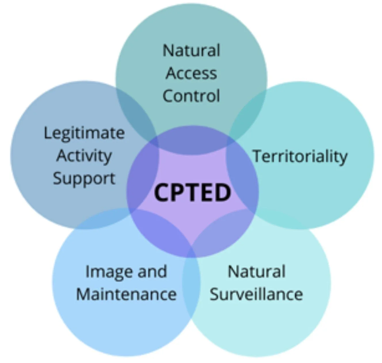
CPTED stands for Crime Prevention Through Environmental Design. It's a method of designing buildings and public spaces to reduce crime.
How it works
Territorial reinforcement: Use signage, lighting, landscaping, and fences to create a sense of ownership
Natural surveillance: Design spaces so people can watch each other, creating a sense of eyes on the street
Clear purpose: Assign a clear purpose to all spaces to avoid creating no-man's land
Visitor reporting: Develop procedures for reporting visitors to larger spaces
Maintenance: Conduct timely maintenance
Benefits
Effective CPTED strategies can reduce crime and calls for service by more than 60%
CPTED can improve public safety and the overall sense of security in a community
Who uses CPTED
Developers: Can use CPTED to reduce crime in their developments
Architects: Can use CPTED to design safer buildings
Law enforcement: Can use CPTED to create safer neighborhoods
Community partners: Can use CPTED to create safer neighborhoods
History
CPTED originated in the United States around 1960
It's been used in law enforcement and city design for decades
Real Possibilities For Growth
A Rail-Trail running from Oneida to Devonia could have significant positive impact on the region, here are some of the highlights.
-
Preserving the historic rail corridor as a trail would invite locals and tourists alike to marvel at the beauty and history of Scott County.
-
Bike shops, shuttle companies, outfitters, lodging, restaurants, and shops are just a few obvious businesses that would be opportunities for local entrepreneurs to create at trailheads or other appropriate locations along the trail route.
-
Sales to tourists visiting the area are already supplying city and county budgets with much needed revenues. Imagine the possibilities of having a top-rated scenic attraction running through Scott County’s towns that have been struggling to find replacements for industries that no longer exist. Imagine further a tourist that is not tearing up trails on ATVs but rather enjoying a leisurely hike, jog or bike ride with their friends and family on a multi-day ride along the 41 miles of path.
